Flight data for HAR130602
Flight details and notes: (As MS Word file)
Left Ogden at approximately 5:40 a.m. in three vehicles, approximately 13.5
team members (0.5 = one child)
Launch Location: Duchesne Airport, U69
40.19667°N, 110.38361°W, 5820 ft ASL
Arrived at launch location at 8:40 a.m., MDT
Manifest and masses:
2000g Balloon
Cutdown = Eckel design, 315g
Parachute = Large, orange/white with hoop, 952g
MSA v3 and v4 in box with external temp sensor and CO2 sensor, 666g
Cameras = two Canon still cameras (16 and 32 GB SD cards), Two GoPros (II & III)
GoPros mounted on ends of wooden booms, total system mass for cameras = 1210g
Two SBATS in blue foam boxes = 368g each
Ozonesonde/radiosonde = 663g
Total Flight Mass including parachute & five packages = 4542g = 9.99lb
Ballast weight (lift) set at 150% = 15lb
Package spacing was approximately 10 feet except the two SBATS were about a foot
apart.
Flight Parameters:
Fill Started at 10:02:30 a.m. MDT
Fill Completed and balloon nozzle tape off started at 10:19:00 a.m. MDT
(approximate)
Fill duration = 16.5 minutes at 30 to 40 psi on the secondary gauge
He used = 1 tank plus 1000psi
Cutdown Set to a delay of: 2.5 hours
Cutdown armed at: 10:23:00
Launch Time: 10:23:35
Burst Time: 11:16:25 Observed burst and was able to visually observe the
parachute at full altitude.
Burst Altitude: 82841ft = 25.250km ASL
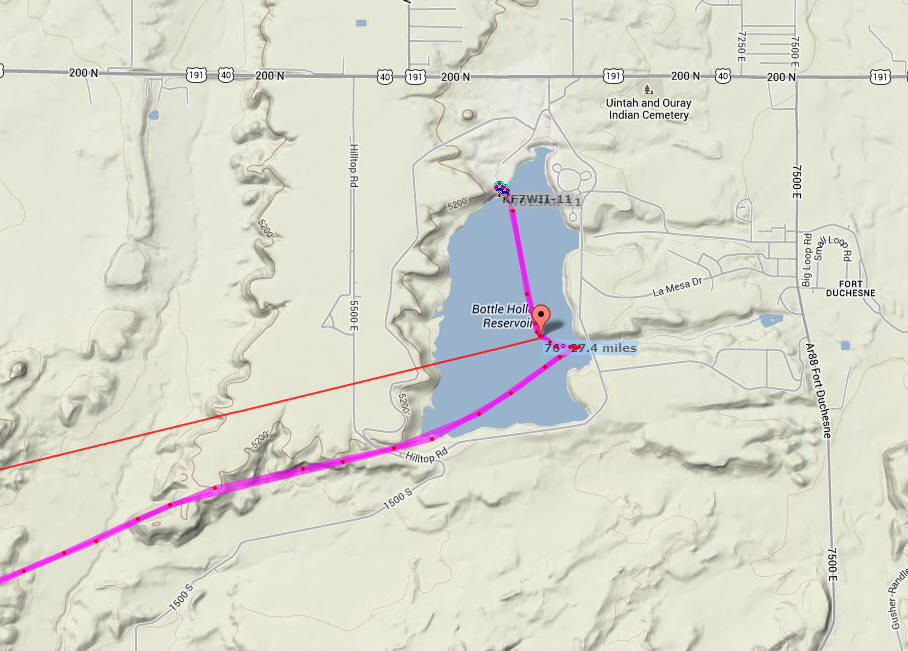
Landing Time: 12:06:50 p.m., MDT, Approximate; landing location 76° at 27.4
miles from launch
Returned Home (Ogden) and completed cleaning the gear and trailer at
approximately 5:30 p.m.
Misc. Notes:
Round trip travel distance in SUV = 379.8 miles
Ozonesonde system needs a better set of antenna cables, precut tubes, better
power system for preamp and radio.
We couldn’t find the new (grey) beacon so we flew without it.
Need to add to the camera checklists: A note to show the GPS time to the cameras
before and after flight.
Obtained ozone data for the duration of the entire flight, both up and down.
Water landing in Bottle Hollow Reservoir, recovered by boaters who saw it
splashdown.
Raw data:
APRS packets WB1 and KF7, KMZ files for Google Earth for WB1 and KF7
MSA version 3, raw data: Sensor data; CO2 data; GPS data
MSA version 4, raw data (with external temperature ( C ), internal temperature ( C ), and internal relative humidity (%RH))
Landing spot map (we "landed" in the middle of the lake and the package was picked up by power boaters who then brought it to the marina where we recovered it; all electronics seem to have survived):