
Flight Data Files for HAR110710; last updated at 7/14/11, 6:39 a.m.
Flight date: July 10, 2011
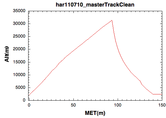
Max Altitude: 103,000 feet = 31.4 km (This is a new HARBOR record altitude.)
Launch Time = 9:32:05 MDT = 15:35:05 zulu (Final value)
Burst Time = 11:05:30 MDT = 17:05:30 zulu (revised preliminary)
Landing Time = 11:53:49 MDT = 17:53:49 zulu (revised preliminary, accurate to +- 7 seconds)
Select ground images. Select flight images.
Master Altitude Track Excel File, Graph image ‑‑‑ Source = Dr. Shane Larson. His notes on this file: I have a cleaning code I use every flight that merges the CATS and BATS tracks, removes bad data points, and then outputs a standard tracking file for input into the "data vs. altitude" splining code. Closer to Raw Data: APRS TNC log; Ground vehicle KMZ file; CATS KMZ file; BATS KMZ file
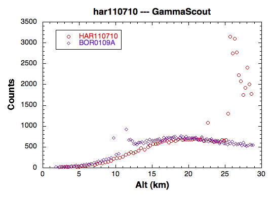
GammaScout Excel File, Graph image ‑‑ Source = Dr. Shane Larson. His notes on this file: This is the GammaScout data, radiation counts vs. altitude. The GammaScout cut out at 82.4 min MET (about 10 minutes prior to burst) at an altitude of 93875 feet (because of the cold, I think). The data however looks quite good ‑‑‑ I don't know about the huge spike in counts above 25km (detector getting cold?), but the lower curve looks great. The peak around 20km is known as the Pfotzer Maximum, and is the peak region where primaries generate secondary showers. I've also included a graph overlaying the BOREALIS data from a 2001 geiger counter flight for comparison.
Particle Detector Files -- Flight Unit setup data, Flight Unit particle counts, Ground Unit setup data, Ground Unit particle counts
Camera Images (as a single 3GB zip file) (Sorry, it's all or nothing at the moment.)
GoPro video files Part 1, Part 2, Part 3, Part 4 (These are the raw video files in MP4 encoding ranging in size from 2 GB to 4 GB.)
Level 0 (unprocessed) data from the Multi-Sensor Array (MSA)